Habitat network at Ledreborg — Example
A worked case in landscape ecology for the course Environmental Regulation and Management with GIS, Theme 2.1 (biodiversity and area-based conservation). Companion: Soil carbon and land use at Ledreborg (Example).
At Ledreborg Gods near Lejre, almost all habitat belongs to one connected network, except on the till plain: it has the least nature (11 %), and 40 % of that nature lies outside the network. Sixteen isolated clusters in and around the study area could be joined to the network with 8 ha of new habitat on farmland. How many clusters there are, though, depends above all on the connection distance chosen.
The case runs through the four phases of the SemanticGIS workflow. Each step is a Task with its own Recipe in QGIS, so the same steps can be repeated on any other study area.
Example data
Everything this example uses, frozen as it was used (27 October 2026), so its numbers can be reproduced without API keys: ledreborg_example_data.zip (2.9 MB), a snapshot package. It holds one GeoPackage with the landscapes, protected nature, woodland, hedges and streams; Basemap04 land use and soil organic carbon (0–30 cm) as 10 m rasters with their styles; the Basemap04 class list (codelists/); and snapshot.json and a README with sources, licences and attribution. The same data serve Habitat network at Ledreborg (Example) and Soil carbon and land use at Ledreborg (Example).
1. Spatial Intent
Question: which parts of the landscape’s nature are connected, which are isolated, and where would new habitat connect them?
Study area: 680077, 6165317 – 686782, 6170607 (EPSG:25832), 6.7 × 5.3 km around Ledreborg Gods, divided into five landscape types (Landscape delineation (Task)).
Theory: a patch-based view of the landscape. Habitat patches in a matrix of farmland, connected where species can move between them, so that the network decides the fate of populations more than any single patch does.
2. Auditing the data
| Nature content | Source | Choice made | Why |
|---|---|---|---|
| §3 protected nature | Miljøportalen, Beskyttede naturtyper | all types (bog, meadow, dry grassland, coastal meadow, lake) | protected habitat by law |
| Larger woodlands | GeoDanmark Skov | at least 5 ha | the data break clearly there: 24 woods ≥ 5 ha cover 1,263 ha, the 215 smaller ones 215 ha |
| Hedges | GeoDanmark Hegn | type Levende only, 5 m wide | 283 of 407 km have no type; the typed living hedges are certain |
| Streams | GeoDanmark Vandløbsmidte | open streams only, 6 m wide | piped stretches are not habitat; 2 m bank zone on each side |
The data were taken for the study area plus 1 km, so the network does not stop artificially at the edge. Land use comes from Basemap04 (lu_agg_2021, 10 m).
3. The Analytical Schema
flowchart LR
  L[Landscape delineation] --> N[Nature content layer]
  N --> D[Distance to habitat]
  N --> H[Habitat network]
  H --> G[Network gaps and stepping stones]
  LU[Land use, Basemap04] --> G
| Task | Recipe | Operator families used |
|---|---|---|
| Nature content layer (Task) | Nature content layer (Recipe - QGIS) | Selection, Proximity, Geometry restructuring |
| Distance to habitat (Task) | Distance to habitat (Recipe - QGIS) | Conversion, Proximity, Zonal |
| Habitat network (Task) | Habitat network (Recipe - QGIS) | Proximity, Geometry restructuring, Zonal |
| Network gaps and stepping stones (Task) | Network gaps and stepping stones (Recipe - QGIS) | Proximity, Overlay, Conversion |
Settings used
The Recipes describe each step in general; these are the settings this example used.
- Landscapes (Landscape delineation (Recipe - QGIS)): a rectangle 680077, 6165317 – 686782, 6170607 (EPSG:25832), split along boundaries read in the geomorphological map, the historical high survey maps (Høje målebordsblade), the 2019 soil map (Jordbundskort), the terrain model with an exaggerated hillshade, and the newest spring orthophoto. 8 polygons of 5 types, 2,704 ha.
- Nature content (Nature content layer (Recipe - QGIS)): sources downloaded for 679077, 6164317 – 687782, 6171607 (the study area plus 1 km): Miljøportalen
dai:bes_naturtyper, GeoDanmarkgdk60:Skov,gdk60:Hegn,gdk60:Vandloebsmidte. Expressions$area >= 50000,"hegnstype" = 'Levende',"vandloebstype" = 'Almindelig'; buffers 2.5 m (hedges) and 3 m (streams). Result: 3,017 patches. - Distance (Distance to habitat (Recipe - QGIS)): 10 m cells, rasterized with
-at. Without-at, 21 % fewer habitat cells, and the share of land more than 100 m from nature rose from 19 % to 22 %. - Network (Habitat network (Recipe - QGIS)): Buffer distance 50 m (connection distance 100 m), also 25 and 100 m (50 and 200 m).
- Gaps (Network gaps and stepping stones (Recipe - QGIS)): clusters of at least 1 ha (
$area >= 10000); strips of 30 m (buffer 15 m, flat ends); possible land = Basemap04lu_agg_2021codes 211000–230000 (agriculture), reclassified and polygonized.
4. Results
Nature content and distance to it
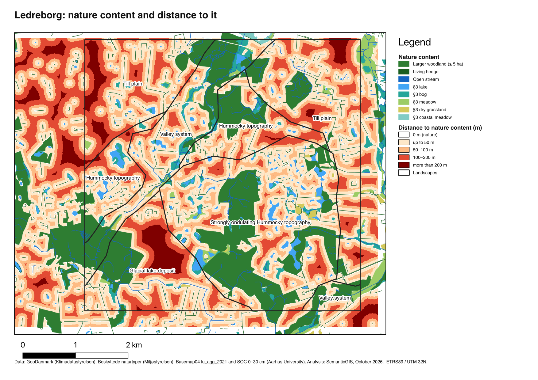
Nature covers 24 % of the study area (869 of 3,547 ha). Woodland dominates; bogs, meadows and lakes lie mostly in the valleys and between the hummocks. 19 % of the study area is more than 100 m from any nature, and nowhere is more than 422 m away.
| Landscape | Area | Nature | Mean distance to nature | Nature in the main network |
|---|---|---|---|---|
| Valley system | 382 ha | 44 % | 26 m | 100 % |
| Strongly ondulating hummocky topography | 843 ha | 38 % | 30 m | 99 % |
| Hummocky topography | 336 ha | 26 % | 45 m | 88 % |
| Glacial lake deposit | 353 ha | 20 % | 83 m | 100 % |
| Till plain | 795 ha | 11 % | 72 m | 60 % |
The network
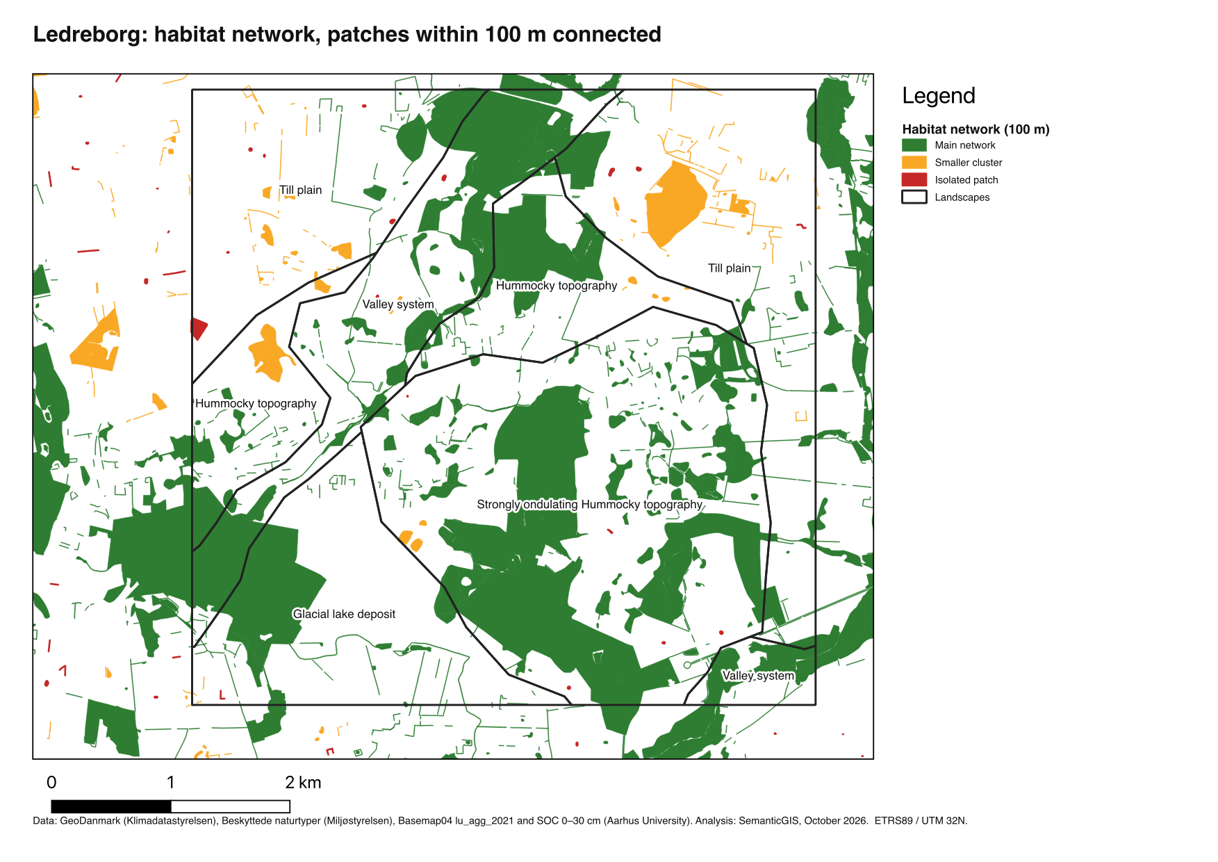
With a connection distance of 100 m, the 3,017 patches form 129 clusters. The main network holds 86.5 % of all habitat area; 66 patches are completely isolated. The choice of distance changes the picture completely:
| Connection distance | Clusters | Isolated patches | Habitat area in the main network |
|---|---|---|---|
| 50 m | 357 | 191 | 37 % |
| 100 m | 129 | 66 | 87 % |
| 200 m | 22 | 12 | 92 % |
Gaps and new habitat
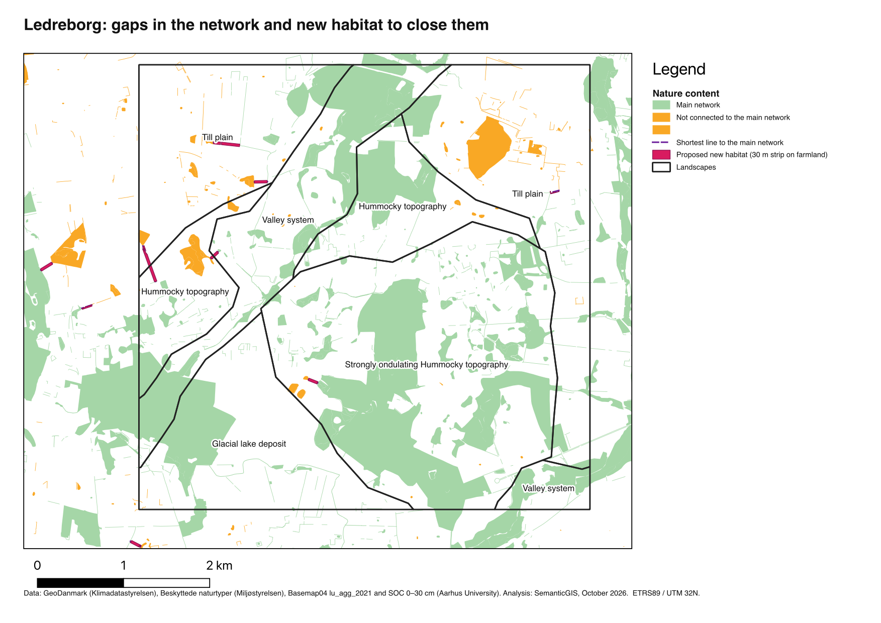
Sixteen clusters with at least 1 ha of habitat lie outside the main network, 102 to 1,250 m from it (median 152 m). Eight of them lie in the 1 km margin around the study area; of the six inside the landscapes, four are on the till plain. A 30 m strip of new habitat along the shortest line, on farmland only, would connect all sixteen with 8.1 ha.
5. Points for the discussion
- “Little nature” and “fragmented nature” are different problems. The glacial lake deposit has only 20 % nature, but it is woodland connected to the network. The till plain has as little, and it is scattered. Regulation aimed at the amount of nature and regulation aimed at connectivity point to different places.
- The connection distance is a modelling choice with ecological content. It should come from the species in question, and a result that only holds at one distance is weak. It is the same kind of problem as the choice of zones in the modifiable areal unit problem (MAUP).
- Patch protection and network. §3 protects each area as a patch; nothing in it protects the gap between two patches. The stepping stones show where planning, rather than protection, would have to act.
- The data shape the network. With all GeoDanmark hedges instead of the typed living hedges, many isolated patches would join the network. A data-quality decision becomes an ecological result.
- Straight lines are a simplification. Roads, the railway and built-up areas are crossed as if they were fields.
Teaching use
The Recipes give every setting, and each ends with check numbers, so students can follow the case on Ledreborg and then repeat it on their own study area. The Epistemic Choices in each Task are the questions their text should answer for their own area.